


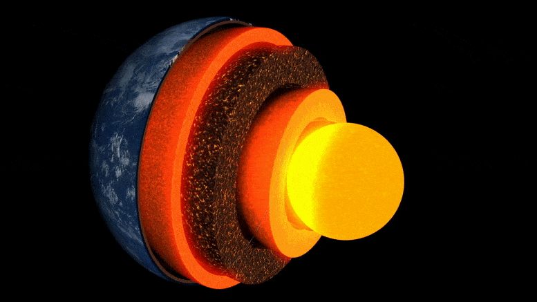
Animacja warstw ziemi.
Nowe badania prowadzone przez Uniwersytet w Cambridge są pierwszymi, które uzyskały szczegółowy „obraz” niezwykłej kieszeni skalnej w warstwie granicznej z jądrem Ziemi, około trzech tysięcy kilometrów pod powierzchnią.
Tajemniczy region skalny, znajdujący się niemal bezpośrednio pod Wyspami Hawajskimi, jest jednym z kilku regionów o bardzo niskiej prędkości – tak zwanej, ponieważ fale trzęsienia ziemi zwalniają, gdy przez nie przechodzą.
Badania opublikowane w czasopiśmie 19 maja 2022 r. Komunikacja przyrodniczajako pierwszy szczegółowo ujawnia złożoną asymetrię wnętrza jednej z tych enklaw, rzucając światło na głębokie wnętrza Ziemi i procesy w nich zachodzące.
„Ze wszystkich głębokich wewnętrznych cech Ziemi, ta jest najwspanialsza i najbardziej złożona”. – jak ja
„Ze wszystkich głębokich wewnętrznych cech Ziemi, ta jest najbardziej fascynująca i złożona. Teraz uzyskaliśmy pierwszy solidny dowód, aby pokazać jej wewnętrzną strukturę – jest to prawdziwy punkt zwrotny w głębokiej sejsmologii” – powiedział główny autor Zhi Li, doktorant na Wydziale Nauk o Ziemi w Cambridge. ground”.
Wnętrze Ziemi jest uformowane jak cebula: w środku znajduje się rdzeń żelazo-niklowy, otoczony grubą warstwą zwaną płaszczem, a powyżej cienka skorupa zewnętrzna – skorupa, na której żyjemy. Chociaż płaszcz jest litą skałą, jest na tyle gorący, że płynie bardzo wolno. Wewnętrzne prądy konwekcyjne dostarczają ciepło do powierzchni, powodując ruch płyt tektonicznych i napędzając erupcje wulkaniczne.
Naukowcy wykorzystują fale sejsmiczne z trzęsień ziemi, aby „zobaczyć” to, co znajduje się pod powierzchnią Ziemi — echa i cienie tych fal ujawniają podobne do radarów obrazy głębokiego wnętrza. Ale do niedawna „obrazy” struktur na granicy jądra i płaszcza, w regionie o podstawowym znaczeniu dla badania wewnętrznego przepływu ciepła naszej planety, były ziarniste i trudne do interpretacji.

Zdarzenia i trajektorie promieni Sdiffa wykorzystane w tym badaniu. a) Przekrój przecinający środek regionu ultraniskiej prędkości na Hawajach, pokazujący trajektorie promieni dla fal Sdiff w 96°, 100°, 110° i 120° dla modelu 1D PREM Earth. Linie przerywane od góry do dołu wskazują nieciągłości 410 km, 660 km i 2791 km (100 km powyżej granicy rdzeń-płaszcz). b) Zdarzenia i trajektorie promieni Sdiffa na modelu tomografii tła SEMUCB_WM1 na głębokości 2791 km. Piłki plażowe na imprezy pomalowane na różne kolory, w tym 20100.320 (żółty), 20111214 (zielony), 20120417 (czerwony), 20180910 (fioletowy), 20180518 (brązowy), 20181030 (różowy), 20161122 (szary), stacje (trójkąty) i promienie. Trajektorie fali Sdiffa na głębokości otworu 2791 km w dolnym płaszczu wykorzystano w tym badaniu. Zdarzenie użyte w analizie krótkookresowej jest podświetlone na żółto. Proponowana lokalizacja ULVZ jest pokazana w czarnym kółku. Linia przerywana przedstawia przekrój narysowany w A. Źródło: Nature Communications, DOI: 10.1038/s41467-022-30502-5
Naukowcy wykorzystali najnowocześniejsze metody modelowania numerycznego do wykrywania struktur w skali kilometrowej na granicy rdzeń-płaszcz. Według współautora, dr Kuangdai Lenga, który opracował metody, gdy w[{” attribute=””>University of Oxford, “We are really pushing the limits of modern high-performance computing for elastodynamic simulations, taking advantage of wave symmetries unnoticed or unused before.” Leng, who is currently based at the Science and Technology Facilities Council, says that this means they can improve the resolution of the images by an order of magnitude compared to previous work.
The researchers observed a 40% reduction in the speed of seismic waves traveling at the base of the ultra-low velocity zone beneath Hawaii. This supports existing proposals that the zone contains much more iron than the surrounding rocks – meaning it is denser and more sluggish. “It’s possible that this iron-rich material is a remnant of ancient rocks from Earth’s early history or even that iron might be leaking from the core by an unknown means,” said project lead Dr Sanne Cottaar from Cambridge Earth Sciences.

Conceptual cartoons of the Hawaiian ultra-low velocity zone (ULVZ) structure. A) ULVZ on the core–mantle boundary at the base of the Hawaiian plume (height is not to scale). B) a zoom in of the modeled ULVZ structure, showing interpreted trapped postcursor waves (note that the waves analyzed have horizontal displacement). Credit: Nature Communications, DOI: 10.1038/s41467-022-30502-5
The research could also help scientists understand what sits beneath and gives rise to volcanic chains like the Hawaiian Islands. Scientists have started to notice a correlation between the location of the descriptively-named hotspot volcanoes, which include Hawaii and Iceland, and the ultra-low velocity zones at the base of the mantle. The origin of hotspot volcanoes has been debated, but the most popular theory suggests that plume-like structures bring hot mantle material all the way from the core-mantle boundary to the surface.
With images of the ultra-low velocity zone beneath Hawaii now in hand, the team can also gather rare physical evidence from what is likely the root of the plume feeding Hawaii. Their observation of dense, iron-rich rock beneath Hawaii would support surface observations. “Basalts erupting from Hawaii have anomalous isotope signatures which could either point to either an early-Earth origin or core leaking, it means some of this dense material piled up at the base must be dragged to the surface,” said Cottaar.
More of the core-mantle boundary now needs to be imaged to understand if all surface hotspots have a pocket of dense material at the base. Where and how the core-mantle boundary can be targeted does depend on where earthquakes occur, and where seismometers are installed to record the waves.
The team’s observations add to a growing body of evidence that Earth’s deep interior is just as variable as its surface. “These low-velocity zones are one of the most intricate features we see at extreme depths – if we expand our search, we are likely to see ever-increasing levels of complexity, both structural and chemical, at the core-mantle boundary,” said Li.
They now plan to apply their techniques to enhance the resolution of imaging of other pockets at the core-mantle boundary, as well as mapping new zones. Eventually, they hope to map the geological landscape across the core-mantle boundary and understand its relationship with the dynamics and evolutionary history of our planet.
Reference: “Kilometer-scale structure on the core–mantle boundary near Hawaii” by Zhi Li, Kuangdai Leng, Jennifer Jenkins and Sanne Cottaar, 19 May 2022, Nature Communications.
DOI: 10.1038/s41467-022-30502-5

„Kawioholik. Fanatyk alkoholu na całe życie. Typowy ekspert podróży. Skłonny do napadów apatii. Internetowy pionier”.

More Stories
Boeing może nie być w stanie obsługiwać pojazdu Starliner przed zniszczeniem stacji kosmicznej
Jak czarne dziury stały się tak duże i szybkie? Odpowiedź kryje się w ciemności
Studentka Uniwersytetu Północnej Karoliny zostanie najmłodszą kobietą, która przekroczy granice kosmosu na pokładzie Blue Origin